On March 11, 2025, the India Meteorological Department (IMD) issued a fresh weather update, predicting heavy rainfall in three districts of Tamil Nadu.
This forecast comes as a cyclonic circulation over the southwest Bay of Bengal brings moist winds and stormy conditions to the state. Residents are bracing for a wet day ahead, with authorities urging caution in the affected areas.
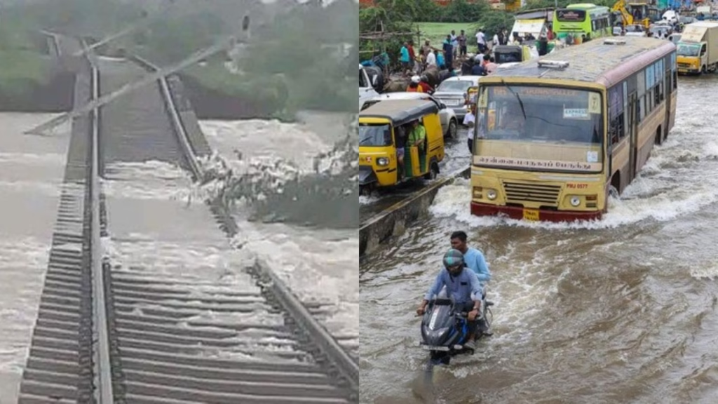
The India Meteorological Department (IMD) has issued a red alert for heavy to extremely heavy rainfall in Tamil Nadu’s Theni, Dindigul, and Tenkasi districts on Thursday. Residents are warned of potential flash floods, landslides, and severe waterlogging, with authorities urging caution near rivers and low-lying areas. Disaster response teams are on standby as schools in vulnerable zones announce preemptive closures to ensure safety.
Why These Districts Are at Risk
Kanniyakumari, known for its scenic beauty and coastal charm, is one of the three districts under the IMD’s heavy rain warning. Located at the southern tip of India, it often bears the brunt of monsoon systems moving in from the Bay of Bengal. Today, the district could see intense rainfall, with the IMD forecasting accumulations that might exceed 64.5 mm in some areas. Local officials are keeping a close eye on low-lying regions, where flooding could become a problem if the rain persists.
Tirunelveli, another district in the spotlight, is no stranger to heavy rains, especially during the northeast monsoon season. With rivers and water bodies already swollen from earlier spells, the predicted downpour could test the region’s drainage systems. Residents are being advised to avoid unnecessary travel and stay updated with weather bulletins. Similarly, Thoothukudi, a coastal hub, is preparing for a wet day. The district’s proximity to the sea makes it vulnerable to sudden weather shifts, and today’s forecast has prompted authorities to monitor fishing activities along the coast.
Theni, Dindigul, and Tenkasi, known for hilly terrains and river systems, are prone to rapid water runoff during heavy rains. IMD officials highlight that the Western Ghats’ wind patterns are channeling moisture-laden clouds toward these districts. “The interaction of easterly and westerly winds is creating unstable weather, leading to extreme rainfall,” said IMD Chennai Director S. Balachandran. Last year, similar conditions caused flooding in Tenkasi, displacing hundreds, a memory that has locals anxious this time.
Immediate Impacts and Precautions
Local administrations have sprung into action, deploying disaster management teams and equipment in high-risk zones. Schools in Theni and Tenkasi will remain shut on Thursday, while Dindigul has banned tourist activities in hilly areas like Kodaikanal. “People should avoid riverbanks and check road conditions before traveling. Emergency helplines (1070, 1077) are active round the clock,” stated Tamil Nadu Disaster Response Agency (TNDRA) chief Rajesh Kumar.
Farmers have been advised to delay crop harvesting, as sudden downpours could damage ready-to-harvest produce. Meanwhile, the state transport department is rerouting buses away from landslide-prone routes, and Southern Railway has installed flood monitors along tracks in Tenkasi.
Past Trends and Climate Concerns
Tamil Nadu has seen a 15% increase in extreme rainfall events since 2020, linked to warming Bay of Bengal waters, according to IMD data. In November 2021, Chennai’s floods claimed over 50 lives, a grim reminder of climate vulnerabilities. While this week’s rain is expected to ease by Friday, experts warn that urban planning must adapt. “Drainage systems in smaller towns like Theni aren’t built for 200 mm rains. Long-term solutions are crucial,” emphasized weather blogger Pradeep John.
How Residents Are Preparing
In Dindigul’s Vathalagundu area, shopkeepers are stacking sandbags to block floodwater entry. “We’ve moved goods to upper shelves after 2019 losses,” said trader M. Selvam. Meanwhile, Tenkasi’s Kannadiparai village residents have formed volunteer teams to alert families near the Gundar River. “We’re using WhatsApp groups to share IMD updates hourly,” shared community leader R. Nandini.
Government’s Response
Chief Minister M.K. Stalin has directed district collectors to coordinate relief operations, with 500 rescue personnel and 65 boats stationed statewide. “Food packets and medicines are pre-positioned in case of isolation,” said Theni Collector K.V. Muralidharan. The government also plans cloud-seeding after the rains to replenish reservoirs, though environmentalists debate its efficacy.
What’s Next?
While the red alert is valid for 24 hours, IMD predicts moderate rains will continue till Saturday. Farmers hope the showers recharge groundwater but fear crop damage. For now, all eyes remain on the skies as Tamil Nadu braces for another watery ordeal.
Why the Sudden Rain?
The current weather pattern is largely influenced by a cyclonic circulation over the southwest Bay of Bengal, a phenomenon that has been intensifying over the past few days. This system is pulling in moist winds from the sea, creating ideal conditions for widespread rainfall across Tamil Nadu. Weather experts, including those from the IMD, have noted that the circulation is expected to move slowly, which could prolong the wet spell in the region. This slow movement often results in heavier and more concentrated rainfall, particularly in coastal and southern districts.
Posts on X from weather enthusiasts echo this analysis, with some predicting “moderate to heavy rains” in delta districts and “very heavy rains” near the Western Ghats. The IMD has also highlighted the possibility of thunderstorms accompanying the rain, adding an extra layer of caution for residents. While the focus is on Kanniyakumari, Tirunelveli, and Thoothukudi today, other parts of Tamil Nadu, like Ramanathapuram and Tenkasi, might also see significant showers as the system evolves.

